Ruahine Circuit
Thursday January 3 – Sunday January 6 2013
Waipawa River/Saddle, Rangioteatua, Waterfall Hut (Day 1). Pinnacle Stream, Iron Peg, Mangaweka, Hikurangi, Crow Hut (Day 2), Rongotea, Wakelings Hut, Maropea Forks Hut (Day 3), Top Maropea Hut, Armstrong Saddle, Sunrise Hut, North Block Road car park (Day 4)
Trampers: Alison Greer, John Dobbs, Geoff Donkin, Les O’Shea and Julia Mackie
Geoff gave us three options for a Ruahine tramp, which we like to do in early January each year. Since the 2005 club trip to Waterfall Hut via Rangioteatua, it has been not been on the trip list, and I was eager to do it. We also all wanted to complete the section of track up Pinnacle Stream up to Iron Peg, which we had not done before. Lastly it was a circuit, so no problems with transport. Thus we all said Yeah to this walk.
 Day 1. We started via the Sunrise track to the junction for Waipawa Forks Hut. Although it is longer than the river route, some of us did not want to get our boots too wet early on. On this section of the Sunrise track, we met the only walkers (going to Sunrise Hut) that we were to meet during the whole four days.
The Waipawa River route at times goes through side banks covered in buddlea and other sharp- stemmed vegetation. At other times, you are river-crossing, and we eventually reached the orange marker which is the start of the steep ascent up to Waipawa Saddle (1326). Near the top of the saddle, we had a breather and reaffirmed that we would go via the tops to Waterfall Hut. It’s a steady climb toward the Three Johns and then around to Rangioteatua (1704), with stops to admire the all round views, and the edelweiss flowering amongst the tussock grass.
 On reaching Rangioteatua, Geoff scouted ahead, looking for the best descent route. It proved to be via a scree slope and gut, which from above looked like it might be difficult. But, when we came to the waterfall, Geoff got down it unaided, and then was able to assist us. Our packs were lowered down first, and then he guided our footholds. We had been expecting a waterfall drop, and were all thankful that we got down it. More scree, and we followed Rangi Creek down, with only one other hairy bit. Walking down the stream, we passed the marker for Rangi Saddle, which is the easier option. An easy walk down Rangi Creek, and we turn the corner and into Kawhatau River. The hut sits on the river bank surrounded by trees.
We all were tired from the longish day, and were soon asleep.

Day 2. The weather did not look too promising; however, we stuck to our plan and headed up Pinnacle Creek. There were cairns here and there to indicate the way up the creek, and nearing the ridge top, the climb was easier. On the ridge, a group photo opportunity was essential, as we had achieved the first step of the day. We could still see Waterfall Hut below, and we congratulated ourselves on our achievement in a good time.

The next stage was to Iron Peg (1703), and we had to cross a slip before climbing up the ridge line. The weather gods had decided to be kind, and we had great views all around again. What a wonderful sight of the main range we had tramped yesterday, and to the north of Waipawa Saddle (just hidden), Te Atuoparapara. On reaching the tarn, we soaked up the views, before heading off for Mangaweka, where we stopped for lunch out of the cold westerly wind.  The tops are broad snow tussock, and we managed to keep on a route which made the going easier, around the base of Hikurangi, from where you can see the track sign for McKinnon Hut. Geoff and I had done this before, and we agreed it seemed easier this time around.
On reaching the McKinnon junction (1625), we opted for the track via the tops rather than McKinnon Hut. We were soon at the junction and able to disrobe from all our wind protective gear. The track is an unrelenting downhill, but we charged onwards.
Goodness, no one at Crow Hut either. The hut, a six-bunker, was in tidy order and has a lot more skylight than Waterfall Hut.
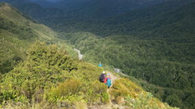
Day 3. We crossed the swing bridge in front of the hut and made for the tops. Fresh legs, and new territory but first we had to negotiate the bluff on the river and steep climb out of it onto the track heading up to Rongotea. Once we emerged from the bushline, Geoff saw two deer on the slopes.  Near the top before reaching the Mokai Patea Range, the track passes a big slip, and at times it was hands and knees through the tussock and low scrub. We again stopped to soak in the views of Ruapehu, and Ngaruhoe, and the flat tops of the Mokai Patea Range, and across to the main range again before reaching Rongotea (1568).

The track down to Wakelings Hut is easy, and we were pleased to be in the bush. On the approach, the Waikamaka River was a welcome sight, as was the newly painted Wakelings Hut. Well done DoC for keeping this hut in good order. We lunched in the shade, and enjoyed a rest before we tackled the last uphill, albeit only a small one, before turning north along the undulating track to Piringa (1317). On the descent, Top Maropea Hut can be seen in the distance.
We are aware of the issues with regard to Maropea Forks Hut, as the river is encroaching. An entry in the hut book indicates that moving the hut has been ruled out. What options are left, we are not sure. The hut is well used by hunters and trampers alike. We hope that a resolution can be found. A wash in the warm afternoon sun, and relax outside on the verandah was welcome.

Day 4. The last day, and we were all getting tired due to previous long days. We took our time tramping up river, and again saw a deer on the scree slopes, and saw the havoc that the river has been causing on the slopes. Slips and tree debris highlight the ongoing erosion caused by rivers. We were on the lookout for the climb-out from the stream, and then saw the big marker on the bank. A quick climb and within 30 minutes, you arrive at Top Maropea Hut. A large grassy area beckoned for an early lunch and view stop. Les opted to stay here for a night, but the rest of us made our way up to junction and then along towards Armstrong Saddle. A beautiful day with 360 views. At Sunrise Hut, we despaired at the lack of housekeeping by some users.
However, we were on the home stretch now, and walked down to close the loop. We were all quiet and tired.
We met some day trippers on their way to Sunrise Hut.
Conclusions:
· Apart from the walkers up/down from Sunrise Hut, we met no one on the four-day tramp. Where were they? We had all carried tents etc, thinking that we would be lucky to get a bed. Instead, we had the huts to ourselves each night.
· We saw lots of deer tracks, in fact we saw three deer, a stoat (live), two hare carcasses, and a mouse.
· We all enjoyed the four days, and achieving our wish list huts and tracks crossing the east/west Ruahine Range.
· We are all getting older and can’t run up hills any more.
· The power of five was good, and kept us all going, and was necessary in the sticky bits.
· We won’t be doing this circuit again, in this direction. Crossing from Purity Hut, Iron Peg, Pinnacle Creek, Waterfall Hut, Rangi Creek, Rangi Saddle, Waikamaka Hut, Waipawa Saddle, is the easier way to make this crossing. Another option would be to descend from Rangioteatua to Rangi Saddle, via a ridge, and then onto the track down to Rangi Creek.
· We saw some wonderful country, and from the tops the views were stupendous.
· The beech forest is wonderfully cool, and a joy to tramp through.
· The huts were all in good condition, however seem under-used. Is the territory too tough for most?
· We all were very pleased with our decision, and thanks to Geoff for his suggestion.

Leave a Reply