Napier Tramping Club

based in Hawke's Bay, New Zealand

Generic selectors
Exact matches only
Search in title
Search in content
Post Type Selectors
Generic selectors
Exact matches only
Search in title
Search in content
Post Type Selectors
  • Home
  • News
  • Recent trips
  • Meetings and Events
    • The Tramp List, and how to book online
    • Club meetings
    • Bike Rides
    • Eezee tramps
  • Gear and fitness
    • Tramping gear details
  • History
    • The Bushbasher archive
    • Memory Lane
  • Contacts
    • Interested in joining

Frozen… hell no, just cold

August 30, 2010 by Alison Greer 1 Comment

Rangiwahia Hut, August 28-29 2010. Map: BL36

Trampers: Sue Marshall, Denise Payne, Ted Angove, Paul Exeter, Les O’Shea, Julia Mackie and Alison Greer

Rangiwahia Hut (or Rangi for short) sits in a hollow just above the bushline on the Whanahuia Range in the western Ruahines. The hut has extensive views over the western and lower North Island, taking in the volcanic plateau and the rugged hills and valleys of the Rangitikei district.

Rangi Hut the following morning

From the car park on Renfrew Road, the track sidles along a ridge through beech then podocarp forest before meeting a large slip. The track deviates up, around, then descends to join a main track just before a lovely arched, oriental-looking bridge. This spans a narrow chasm about 70 metres deep and is a great photo spot. From here, the track climbs (at times steeply) over a mixture of rocks, tree roots and zigzags, crosses below a small waterfall and then emerges onto a broad tussock ridge. The 12-bunk, serviced Rangiwahia Hut is then within sight and takes only a few moments more to reach.

Four of the group had taken this route, with three deciding to take the alternative Deadmans track route. This track starts from the car park but climbs up the ridge to the south. It’s well marked and leads up through beech, podocarp, and hardwood forest with the fabulous mountain cedar making an appearance.

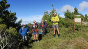
Climbing steeply at first, the track flattens out before climbing again at a gentler gradient through a corridor of sub-alpine scrub and leatherwood. On reaching the open tussock, you can look across the valley and see the ridge that leads down to Rangiwahia Hut. For us, it was time to put on extra layers as the wind was cool and the predicted weather change was on its way. Snow lay between the tussock and got deeper the higher you went, making the going much harder. We had a very quick lunch by the tarn, checked the map for our position, and more layers were put on before the last ascent to the signpost on Mangahuia at 1583m, the high point of the day. We seemed to have steered clear of the dark clouds all day.

Alison Greer and Julia Mackie, frozen in time

Photos were swiftly taken of some great views, as it was too cold to linger; then it was down the poled, snow-covered ridge trying to keep to the clumps of tussock for better footing. Les was going like a bat out of hell, as he was very cold. We all managed to fall over at some stage, with one or two full face-plants thrown in. We could see in the distance three members of the other group who had come up to meet us and were watching our progress. We met up and they were impressed that it had only taken four hours to do the loop.

Les crossing the arched bridge on our way out

With the weather closing in, we made our way down to the hut where the gas heater was going and the kettle was on. That night, we shared the hut with four women from Wellington and in the morning had an uneventful walk out to the car park.

Filed Under: Recent trips Tagged With: Deadmans Track, Rangiwahia Hut, Whanahuia Range

Comments

  1. A J G says

    October 14, 2010 at 8:33 am

    I just don’t understand how a non-tramper can be awarded a club cup!
    C’mon Brian; it’s time you became a ‘real tramper ‘!
    Cheers

    A.Non

Leave a Reply

Your email address will not be published. Required fields are marked *

Our most recent trips

A damper on our day trip: Cloud turns to mist, mist becomes drizzle, then it pours

Black Birch Ridge, Kaweka Forest Park, Wednesday 14 May 2025 Banner Photo: A soggy snack break at Black Birch bivouac The trip originally planned … Read More

A blue-bird day for reaching the Kaweka tops

Kaweka J, Saturday 10 May 2025 Banner Photo: Heading back from North Kaweka Eleven keen trampers met at Park Island on a cool but potentially … Read More

Walking back in time on an old Māori trail

Matemateāonga Track, Whanganui National Park, Anzac Weekend, 25-27 April 2025 Banner Photo: The sunrise from Pōuri Hut Tramp organiser Sue Martin … Read More

News

May 2025 News

May 1, 2025 By The Editor Leave a Comment

The NTC AGM was held on 22 May. The officer positions for the club are: Di Reid - President, Sue … Read More

April 2025 News

April 2, 2025 By The Editor Leave a Comment

The AGM for 2025 will be held on 22 May. Where we're headed in 2025 The first six-months' … Read More

About us

We are a group of like-minded people who love the great outdoors. We tramp mostly in the Hawke’s Bay province, in remote areas such as the Kaweka and Ruahine Ranges; but we also travel longer distances to new places, for longer walks.

The Napier Tramping Club was established in 1974 and has about 70 members. We belong to the Federated Mountain Clubs of NZ Inc (FMC) and run Saturday, full-weekend and Wednesday tramps, every fortnight.

Interested in joining us?

Enjoy the great outdoors, keep fit and get to know others with similar interests.

More information

Latest news

May 2025 News

The NTC AGM was held on 22 May. The officer positions for the club are: Di Reid - President, Sue … Read More

April 2025 News

The AGM for 2025 will be held on 22 May. Where we're headed in 2025 The first six-months' … Read More

Latest trip

A damper on our day trip: Cloud turns to mist, mist becomes drizzle, then it pours

Useful links

  • Dept of Conservation
  • DoC Huts Use, Kaweka Forest Park
  • Federated Mountain Clubs of NZ (FMC)
  • Heretaunga Tramping Club
  • New Zealand Tramper
  • NZ Walking Access Commission
  • Wanganui Tramping Club

Useful links 2

  • Royal Forest & Bird Protection Society
  • Taraponui i-Networks camera
  • Weather forecast

Copyright © 2025 · Napier Tramping Club · Sign In · Website by D2 ·